Reimagining Superior Avenue - Part I
Should Superior Avenue be as wide as it is?
The short answer is no. Many people say this, citing the width of the street; it is approximately 130 feet wide on the section running from W. 9th Street to E. 55th. In particular, the part of Superior that runs through Downtown feels much wider than it needs to be. While the sidewalks are extensive here, the roadway is very large and needs to provide more space for people on bikes. Additionally, while there is a “bus lane” running from East Roadway to about E. 17th, it is in a poor state of repair.
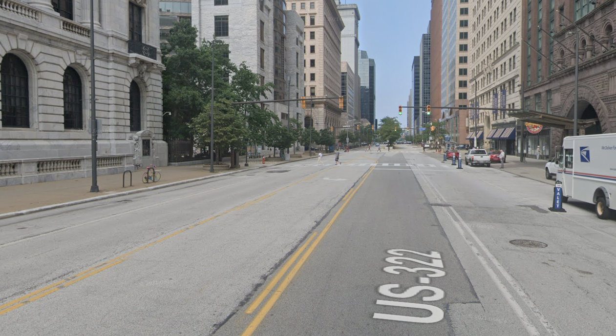
Why on Earth is this road so wide with so little traffic? In the middle of Downtown, too! Source: Google Maps
One major case for reducing the number of lanes for cars on Superior is that there simply isn’t enough traffic to justify the current division of space. According to the Ohio Department of Transportation TMMS, a repository for traffic count data, no section of Superior in Downtown sees more than about 10,000 vehicles per day. According to a source from the US DOT, this is under the threshold for being able to implement a road diet, in this case reducing the number of lanes dedicated to cars to 1 in each direction. While this is already the configuration in the Downtown section of the roadway east of Public Square, there is no reason why this configuration could not be extended or modified.
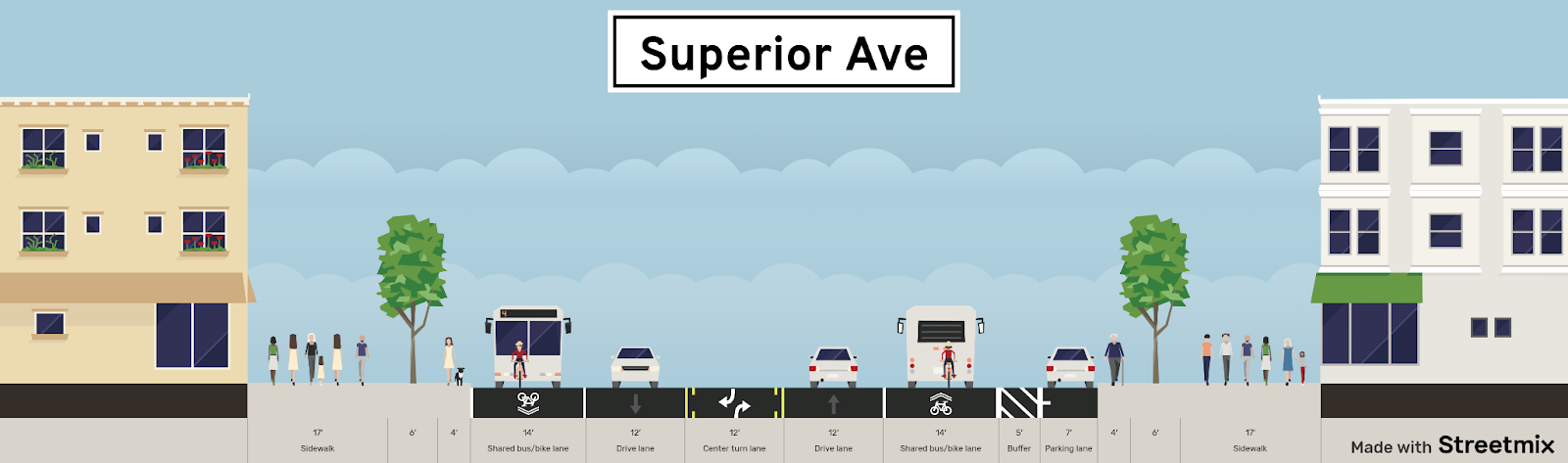
This is what the current setup of Superior looks like between Public Square and E. 6th Street. Note that the traffic lanes are very wide and that there is a lot of wasted space in this configuration.
The upcoming Superior Midway project, which will add a protected cycle track down the center of the street, will come online sometime in the next few years. Taking this into consideration, I wondered what other modifications could be made to the street to make it more walkable and more transit-friendly.
Making Superior a multimodal corridor
What are the changes that could be made to improve Superior Avenue through Downtown Cleveland? One main idea that comes to mind is that the street should have more permanent dedicated bus lanes. Currently, as can be seen in the cross-section above, the street does have bus lanes; however, they are frequently blocked by double-parked cars, valet lines, and delivery vehicles. Considering that many bus routes travel along this section of the road, removing these obstacles is a necessity.
While bus rapid transit (BRT) is often maligned due to poor implementation (as in the case of the Healthline), this style of service can be an effective way to build capacity while providing more comfortable infrastructure. Due to its width, Superior would be a great candidate for a future BRT line. This type of configuration would also eliminate the possibility of vehicles stopping at the side of the road and blocking the bus.
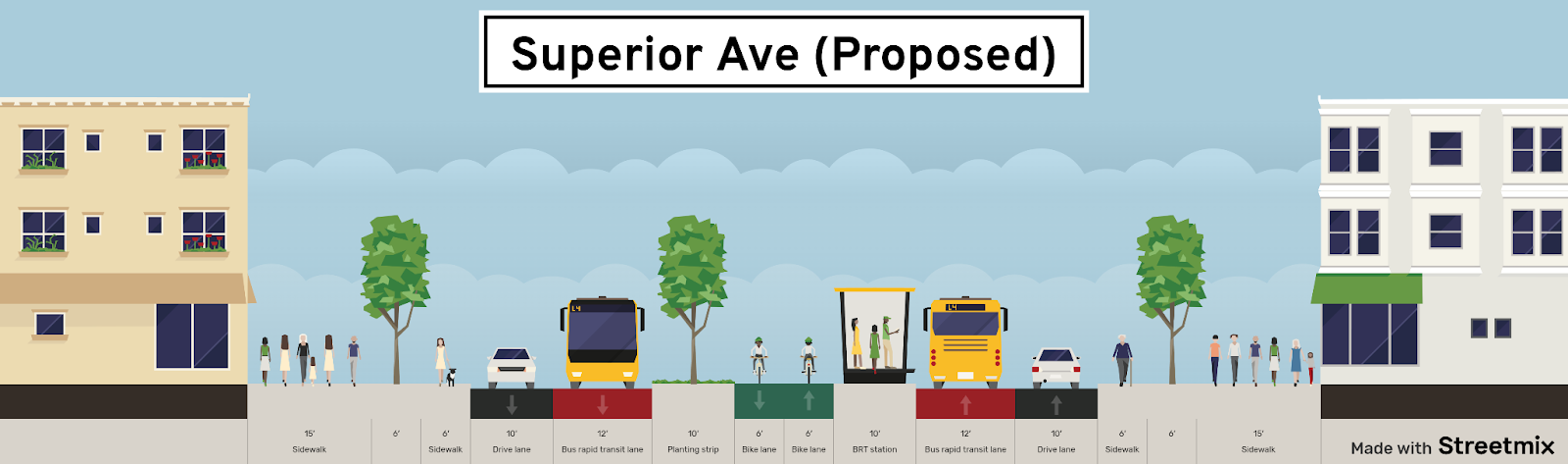
This is my proposal for how a redesigned Superior Avenue could look, with the Midway and BRT line, while maintaining wide sidewalks. This view shows how BRT stations can fit into the landscape.
The proposal that I have drawn up here shows how, on a street as wide as Superior, it is entirely possible to create both protected bike infrastructure and dedicated bus lanes. This new design significantly increases the total capacity of the street, especially because of having BRT. In this configuration, the cycle track is wide and is protected by planted buffers that can accommodate the width of a bus platform at intersections. Of course, this is an expensive form of transportation investment; however, this is truly the type of investment that this city needs. Superior is already a major street for bus routes, so it makes a lot of sense to add the BRT along this important transit corridor.
What this means for people
For too long cities have been designed around accommodating cars. This needs to change for cities to be made for people. In Cleveland, we have a massive network of wide arterial streets that were built when the city’s population was still 900,000. This is precisely why projects have been proposed on many of these streets because we have more space for cars than we need.
Superior has always been a wide street. It was designed that way more than 150 years ago. However, it wasn’t until cars came about that this width was a problem. In a city where achieving more walkable and bikeable neighborhoods is a goal, projects like this must be undertaken to make places hospitable again.
What’s next?
Part two of this narrative will be shared in one week, on July 14th. The second part will focus on visualizing these designs, as well as how implementation could be undertaken. This will include site plans and renderings, along with cost estimates, potential funding sources, and ideas on how to connect this infrastructure outside of Downtown.
Thanks for reading!
Comments
Post a Comment